.png?lang=en-US&width=549&height=399&ext=.png)
Local flash flood warnings have expanded northward during the afternoon to include all of western Kentucky, and Massac and southern Pope counties in Illinois until 7:45 p.m.
The National Weather Service has used terms like "catastrophic," "historic," "life-threatening" and "a particulary dangerous major flash flood event" to describe what has been happening, and what will continue this evening through late tonight here and across Kentucky..
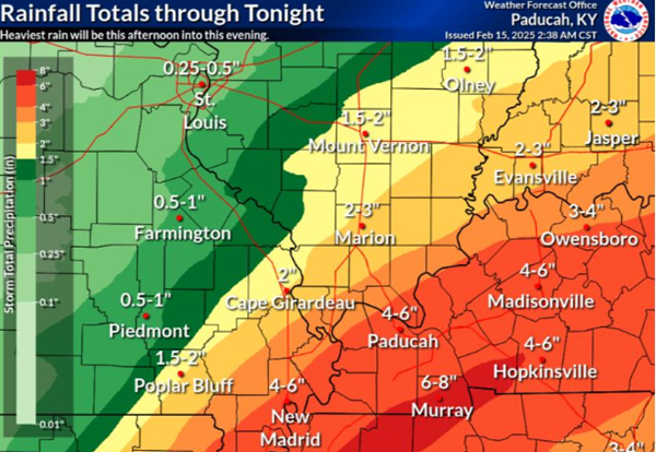
Most of western Kentucky, especially nearer to the Tennessee line, has already experienced flash flooding with 2 to 3 inches of rain. An additional average of 2 to 3 more inches is expected, and flash flooding conditions will worsen.
A band along southern Graves, Calloway and Trigg counties have already exceeded 3 inches of rain, and are projected to get a possible 6 to 8 inches of rain before it concludes late tonight.
Some thunderstorms this afternoon and evening may become severe in areas along the Kentucky-Tennessee border. Damaging wind gusts and possibly a brief tornado or two are the main threats.
Flash flood warnings are in effect for the entire length of the Kentucky-Tennessee state line. The entire state of Kentucky is under a state of emergency declared by the governor on Friday.
Advertisement
Flash flood warnings expand; severe thunderstorms possible til 9PM
Advertisement
Latest Local & Regional
Local & Regional
an hour ago

Local & Regional
4 hours ago
Local & Regional
18 hours ago

Local & Regional
yesterday

Local & Regional
yesterday

ADVERTISEMENT
Most Read >
ADVERTISEMENT
Latest Local & Regional
Local & Regional
an hour ago
Local & Regional
4 hours ago
Local & Regional
18 hours ago
Local & Regional
yesterday
Local & Regional
yesterday
Advertisement
ADVERTISEMENT