.png?lang=en-US&width=600&height=404&ext=.png)
The rest of today looks to be very marginal in nature, with scattered storms expected to pop up until 6 p.m. Some of the stronger cores may produce some damaging wind.
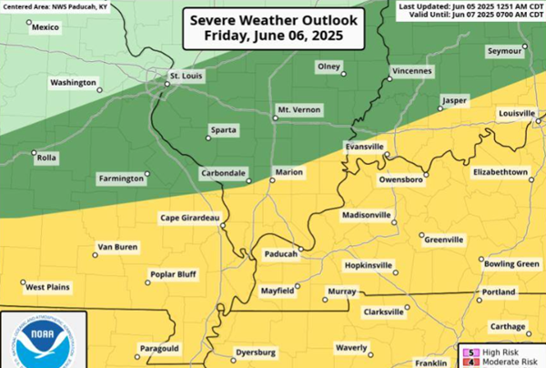
Friday looks to be more organized as a cluster of storms moves through the area with all modes of severe possible. Prime time of concern will be from 10 a.m. until about 2 p.m. Concerns will be for damaging winds, large hail and an isolated tornado.
Saturday looks to be very similar to Friday.
Three to four inches of rain fell in Carlisle and Hickman counties this morning, then moved into northwest Tennessee. Water was reported over a few roads this morning, including KY 307 north of KY 121.
MAP: Friday's chance for severe weather. (National Weather Service)
Advertisement
Stronger chance for severe weather Friday into Saturday
Advertisement
Latest Local & Regional
Local & Regional
4 hours ago

Local & Regional
5 hours ago

Local & Regional
5 hours ago

Local & Regional
10 hours ago
Local & Regional
11 hours ago

ADVERTISEMENT
Most Read >
ADVERTISEMENT
Latest Local & Regional
Local & Regional
4 hours ago
Local & Regional
5 hours ago
Local & Regional
5 hours ago
Local & Regional
10 hours ago
Local & Regional
11 hours ago
Advertisement
ADVERTISEMENT