
As summer comes to a close this weekend, drought conditions have expanded over the lower Ohio Valley and indeed the eastern half of the nation.
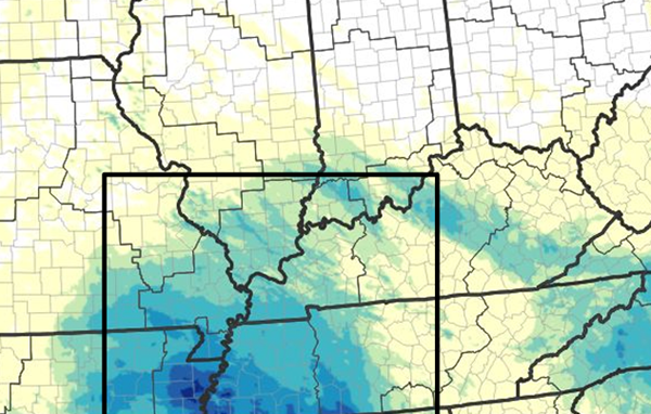
Most locations have seen below normal rainfall since the beginning of August, and even the remnants of Hurricane Francine failed to bring relief to our region. That system stalled in Arkansas and only southwestern Kentucky ended up with more than two total inches of rain.
According to the USDA's latest drought monitor, only a small sliver of Missouri and Kentucky benefited from Francine, including Hickman and Fulton counties. Drought conditions worsened from moderate to severe in much of western Kentucky, and all of southern Illinois is experiencing at least moderate drought.
West Tennessee overall is even drier, with a few counties in extreme drought. Much of the nation continues to be abnormally dry from Iowa to Alabama and Kansas to Virginia.
The chance for some relief starts to build this weekend into next week. A very few isolated showers could form today and tonight, but more widespread shower and thunderstorm activity will hold off until Sunday into Monday.
In concert with the arrival of fall on Sunday, much cooler conditions will also return for the middle of next week, dipping below 80 by Wednesday.
MAPS: USDA drought monitor as of 9/19; rainfall from Francine remnants (NOAA/USDA)
Advertisement
No help from Francine; drought expands across the region
Advertisement
Latest Local & Regional
Local & Regional
3 hours ago

Local & Regional
3 hours ago

Local & Regional
4 hours ago

Local & Regional
9 hours ago
.png?lang=en-US&width=600&height=404&ext=.png)
Local & Regional
10 hours ago

ADVERTISEMENT
Most Read >
ADVERTISEMENT
Latest Local & Regional
Local & Regional
3 hours ago
Local & Regional
3 hours ago
Local & Regional
4 hours ago
Local & Regional
9 hours ago
Local & Regional
10 hours ago
Advertisement
ADVERTISEMENT