Meteorologists at the National Hurricane Center in Miami are keeping a close eye on a tropical disturbance in the Atlantic Ocean.
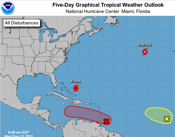
For now, the tropical wave known as Invest 98-L is located several hundred miles east of the Windward Islands, but it's showing signs of organization.
Experts are confident that it will likely become a tropical depression within the next two or three days.
The disturbance is forecast to move toward the central Caribbean Sea later this week.
The National Hurricane Center gives the system a 70% chance of formation in 48 hours and a 90% chance of formation in five days.
Once in the Caribbean, the next focus will be on whether the new depression would turn northward toward the Gulf of Mexico.
Very preliminary computer models are tracking the storm to a wide range of possible paths, from Belize in Central America, to Cancun in Mexico to Havana, Cuba.
The next named storm would be called Hermine.
Tropical disturbance Invest 98-L (red X) is only beginning to move toward the Caribbean and potentially the Gulf of Mexico. (Map courtesy of National Hurricane Center)
Advertisement
Tropical disturbance may pose threat to Gulf next week
Advertisement
Latest State & National
State & National
6 hours ago

State & National
6 hours ago

State & National
11 hours ago

State & National
11 hours ago

State & National
22 hours ago

ADVERTISEMENT
Most Read >
ADVERTISEMENT
Latest State & National
State & National
6 hours ago
State & National
6 hours ago
State & National
11 hours ago
State & National
11 hours ago
State & National
22 hours ago
Advertisement
ADVERTISEMENT