
The National Hurricane Center has designated Potential Tropical Cyclone Nine in the western Caribbean. It's expected to develop into a tropical storm later today, then quickly grow to become Hurricane Helene.
Confidence is high that the future Helene will become a dangerous and destructive hurricane for the state of Florida and southern Georgia. Hurricane, Tropical Storm and Storm Surge Watches are now in place across Florida. Starting this evening, these will become warnings.
Impacts from Helene will begin on Wednesday as its outer bands reach south Florida and the Keys. Thursday will be the main impact day as the storm rapidly strengthens on approach to the Big Bend region.
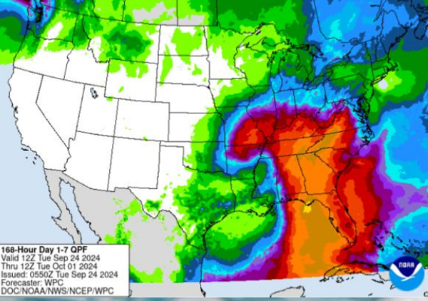
After that, almost all of the computer-generated "spaghetti models" say that the remnants of Helene will track north, then west to our region. Various models put the tropical depression anywhere from Memphis to Evansville by Saturday.
No matter the specific location, our general forecast will be for chances of heavy rain onThursday and Friday, then lingering rain possible over the weekend.
Advertisement
Future hurricane Helene's remnants forecast to come our way
Advertisement
Latest State & National
State & National
an hour ago

State & National
2 hours ago
State & National
15 hours ago

State & National
15 hours ago
.png?lang=en-US&width=583&height=450&ext=.png)
State & National
23 hours ago

ADVERTISEMENT
Most Read >
ADVERTISEMENT
Latest State & National
State & National
an hour ago
State & National
2 hours ago
State & National
15 hours ago
State & National
15 hours ago
State & National
23 hours ago
Advertisement
ADVERTISEMENT