
Just as we transition into the first week of fall, cool and wet are the new watch words for our region.
The combination of an upper level low and moisture from pending tropical system Helene will bring widespread moderate to heavy rainfall to much of the area this week and weekend.
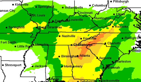
While changes to the forecast remain possible, 2-3 inches of rainfall is expected across most of the area through Sunday. Locally higher amounts are possible.
Widespread cloud cover will keep temperatures cool the rest of the week.
Remnants of Tropical Storm Helene -- soon to be a hurricane on Wednesday -- will move north quickly after landfall in Florida on Thursday.
The Tuesday night cone of the remnants' expected path still point toward the tropical depression to be over southern Illinois by Saturday afternoon.
The heaviest rains from Helene look to be heading for east Tennessee and the western Carolinas, where eight or more inches could fall into steep Appalachian valleys. A five-state flood watch has already been issued through Friday afternoon.
Advertisement
Wet, cool week wraps up with more hurricane remnants
Advertisement
Latest Local & Regional
Local & Regional
2 hours ago
Local & Regional
10 hours ago

Local & Regional
10 hours ago

Local & Regional
10 hours ago

Local & Regional
11 hours ago

ADVERTISEMENT
Most Read >
ADVERTISEMENT
Latest Local & Regional
Local & Regional
2 hours ago
Local & Regional
10 hours ago
Local & Regional
10 hours ago
Local & Regional
10 hours ago
Local & Regional
11 hours ago
Advertisement
ADVERTISEMENT