
Another major severe weather outbreak is anticipated Wednesday afternoon and evening. The enhanced risk for storms (level 3 out of 5) means that strong tornadoes, very large hail, and damaging winds will all be possible.
As the storms approach on Wednesday, a wind advisory will be needed when gusts build to over 40 miles per hour. A flood watch is already in place for the continued heavy rains to follow.
If Wednesday evening's supercells remain isolated, strong long-tracked tornadoes would be possible. Conditions will also be in place for hail of 2 inches or larger, and damaging winds over 60 miles per hour.
The key to prolonged weekend rain totals will be where the storm front is located when it stalls out over the region, then produces waves of heavy rainfall through Saturday.
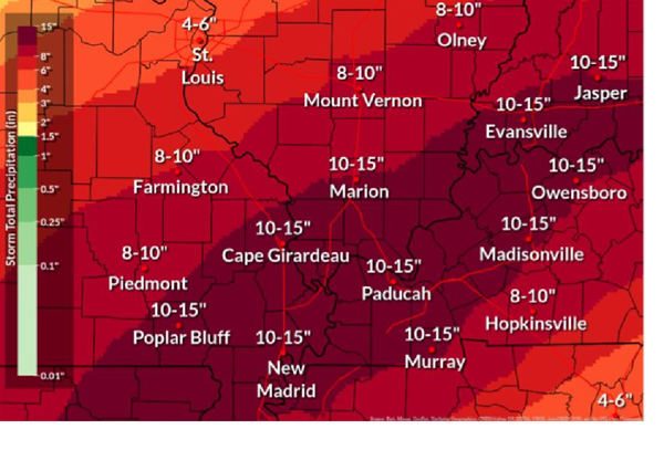
Total rainfall models now range from at least 7 to 10 inches over the Quad State, with 10-12 likely over most of the region. The greatest amounts look to be straddling the Ohio River. Friday night or Saturday could be when the heaviest and most widespread rain falls.
Those historically high forecast rainfall amounts will lead to significant and widespread flooding Wednesday through Sunday. These amounts will cause flooding in areas that don't normally flood, and in some spots that have never flooded before.
The extended 8-14 day outlook indicates drier and cooler than normal conditions next week.
On the Net:
National Weather Service Paducah - Facebook page

.jpg?lang=en-US&width=600&height=540&ext=.jpg)

