
The forecast is firming up for possible severe weather on Saturday, according to the National Weather Service in Paducah.
Thursday and Friday will be the last warm and dry days of a spectacular week, with highs in the low 80s.
Thunderstorms with heavy rainfall will be possible on Saturday, mostly from the afternoon into Saturday night. The intensity could be enough to trigger flash flooding in low-lying or flood-prone locations. Saturday's high will still be a warm 84.
As for severe weather potential, a lack of instability may limit severe storm development. If severe storms do develop, damaging winds would be the primary concern. Otherwise, it could be more of a heavy rain event.
The rain tapers off early Sunday, and a gusty northwest wind will push temperatures down to 67 on Sunday afternoon, then 47 Monday morning.
Cooler 70s are expected next week, and a slight chance of showers returns for Tuesday.
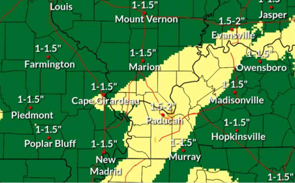
MAP 1: chance and location for excessive rainfall. MAP 2: up to 2 inches of rain possible Saturday and Sunday (National Weather Service)
Advertisement
Saturday storms could contain damaging winds, flash flooding
Advertisement
Latest Local & Regional
Local & Regional
4 hours ago
Local & Regional
9 hours ago

Local & Regional
9 hours ago

Local & Regional
13 hours ago

Local & Regional
yesterday

ADVERTISEMENT
Most Read >
ADVERTISEMENT
Latest Local & Regional
Local & Regional
4 hours ago
Local & Regional
9 hours ago
Local & Regional
9 hours ago
Local & Regional
13 hours ago
Local & Regional
yesterday
Advertisement
ADVERTISEMENT