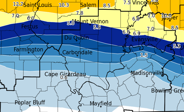
The National Weather Service in Paducah has been able to take a moment to tally the totals of how much ice from freezing rain was received across southern Illinois and western Kentucky over the weekend.
Most of western Kentucky received a tenth to a quarter of an inch of ice, with lower totals in Hickman and Fulton counties.
North of the lakes in Livingston, Caldwell and southern Crittenden counties, ice ranged from a quarter to a half an inch, as did the southernmost Illinois counties along the Ohio River.
The rest of southern Illinois, along with northern Crittenden County, are included in a band where up to three-fourths of an inch of ice came down. At its peak, more than 100,000 residents were without power in southeast Missouri, southern Illinois, northwestern Kentucky and southwest Indiana on Sunday night into Monday morning.
Further to the north, heavy snow was the main product of the storm. Accumulation ranged from 1.5 inches in Carbondale to 5.5 inches at Mt. Vernon, 6.9 inches at Evansville, and more than 10 inches northeast of St. Louis.
Advertisement
Ice totals up to 3/4 inch in southern Illinois, Crittenden County
Advertisement
Latest Local & Regional
Local & Regional
22 minutes ago
Local & Regional
10 hours ago
Local & Regional
13 hours ago
Local & Regional
16 hours ago
Local & Regional
18 hours ago
ADVERTISEMENT
Most Read >
ADVERTISEMENT
Latest Local & Regional
Local & Regional
22 minutes ago
Local & Regional
10 hours ago
Local & Regional
13 hours ago
Local & Regional
16 hours ago
Local & Regional
18 hours ago
Advertisement
ADVERTISEMENT


