
Record rainfall caused widespread flash flooding across the St. Louis area Tuesday morning, closed multiple roadways and prompted rescues from vehicles stranded by high waters.
There were no immediate reports of injuries in the heaviest rainfall in over 100 years for the city.
Parts of all four interstates were reported flooded and closed in the downtown area. Rising waters threatened homes in the suburb of Ladue.
Rainfall of between 6 to 10 inches was reported since last night, the National Weather Service said on Twitter.
St. Louis recorded more than 7 inches of rainfall Tuesday morning, surpassing the record of 6.85 inches from remnants of a hurricane on Aug. 20, 1915.
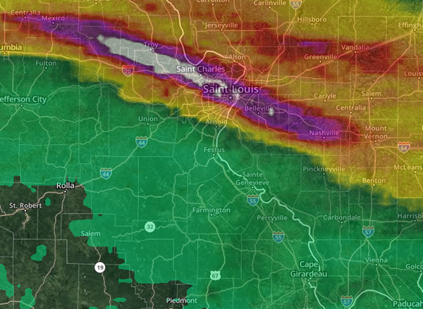
Time-lapse radar indicated that a stretch northwest of St. Louis received even more rain since yesterday, over 13 inches as indicated by the radar returns. Totals tapered off gradually through Illinois to still more than 7 inches near Nashville and Okawville.
The St. Louis Fire Department had to perform water rescues from homes and vehicles.
Several streets in University City, Maplewood, and St. Louis City were deemed impassable.
The Maryland Heights Community Center opened as an emergency shelter for residents.
The Gateway Arch had to be closed all day due to the flooding caused by the record rainfall.
The long swath of storms continued through central and southern Illinois, where flash flooding from up to 3 inches of rain occurred north of Marion, Carbondale and Harrisburg.
Advertisement
Historic flooding in St. Louis
Advertisement
Latest State & National
State & National
7 hours ago

State & National
13 hours ago

State & National
yesterday

State & National
Mar. 21, 2025

State & National
Mar. 20, 2025

ADVERTISEMENT
Most Read >
ADVERTISEMENT
Latest State & National
State & National
7 hours ago
State & National
13 hours ago
State & National
yesterday
State & National
Mar. 21, 2025
State & National
Mar. 20, 2025
Advertisement
ADVERTISEMENT