A significant warmup today will precede the approach of another cold front, bringing the chance for a few strong storms tonight.
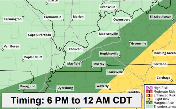
After a high of only 77 on Thursday, the temperature today will rebound to around 89 before scattered thunderstorms develop late this afternoon through tonight across western Kentucky. A few storms could become severe, with damaging wind gusts of 60 miles per hour and large hail being the main threats.
The severe risk will be greatest between roughly 6 PM to midnight tonight.
Rainfall amounts will range generally from 0.25 to 0.75 inches, which will help a little bit with our ongoing drought conditions.
After weekend highs around 80, another extended period of dry and increasingly hot weather is forecast through next week, but that return should be a dry one that is not too humid.
Advertisement
Some strong storms possible tonight
Advertisement
Latest Local & Regional
Local & Regional
3 hours ago

Local & Regional
3 hours ago

Local & Regional
7 hours ago
Local & Regional
13 hours ago

Local & Regional
23 hours ago

ADVERTISEMENT
Most Read >
ADVERTISEMENT
Latest Local & Regional
Local & Regional
3 hours ago
Local & Regional
3 hours ago
Local & Regional
7 hours ago
Local & Regional
13 hours ago
Local & Regional
23 hours ago
Advertisement
ADVERTISEMENT