
September was one of the driest ever in Paducah, and the trend will continue into October.
The National Weather Service said it was the 6th-driest September ever for Paducah, and the 4th-driest for Cape Girardeau.
Moderate drought conditions have expanded in the past few weeks from McCracken and Massac to Ballard, Carlisle, northern Graves and northern Hickman counties, as well as all of southernmost Illinois and most of southeast Missouri.
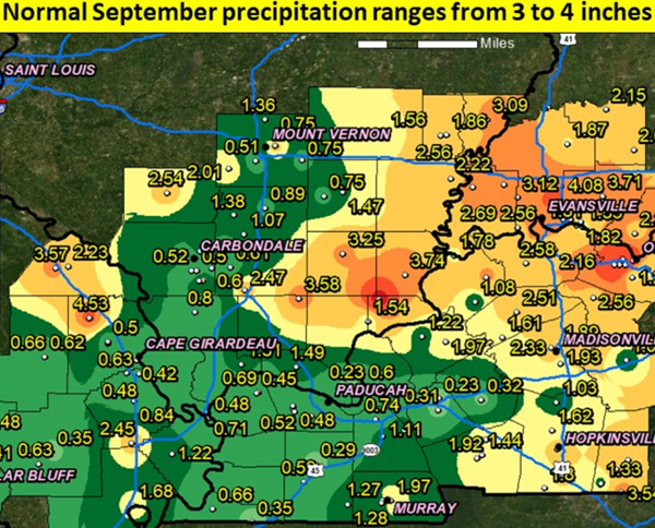
The vast majority of our region experienced an abnormally dry month, where most areas struggled to pick up more than 2 inches of rain the entire month. It was especially true across southeast Missouri, the Jackson Purchase of western Kentucky, and far southern Illinois where many areas only received one-half to an inch. Paducah's .66 inch rain total was almost three inches shy of normal precipitation for the month.
Records were also set in Paducah for the latest dates to reach triple-digit highs, on September 19 through 21.
While the extreme heat is gone, the dusty dry conditions will continue for yet another week.
Next weekend doesn't include a mention of rain, but it does note morning lows reaching into the 30s.
Paducah's average first freeze is usually around Oct. 26.
DROUGHT MAP shows abnormally dry counties in yellow; counties experiencing moderate drought conditions are in tan.
PRECIPITATION MAP for September at various National Weather Service weather stations.
Advertisement
Drought expands after Paducah's 6th-driest September ever
Advertisement
Latest Local & Regional
Local & Regional
3 hours ago

Local & Regional
4 hours ago

Local & Regional
5 hours ago

Local & Regional
6 hours ago

Local & Regional
6 hours ago

ADVERTISEMENT
Most Read >
ADVERTISEMENT
Latest Local & Regional
Local & Regional
3 hours ago
Local & Regional
4 hours ago
Local & Regional
5 hours ago
Local & Regional
6 hours ago
Local & Regional
6 hours ago
Advertisement
ADVERTISEMENT