Our transition into fall accelerates next week with the arrival of a cold front on Sunday.
This week's afternoon highs in the 70s are turning out to be just a short path to a round of days in the 60s, starting with 65 on Columbus Day Monday. In fact, upper 50s are even possible in some spots midweek. Our historical average high is 72 degrees.
That will also usher in a corresponding drop in morning lows to 41 on Monday in Paducah. Lows in places to the middle to upper 30s will bring the first potential frost of the season to parts of the region. Next week's usual low is 59 degrees.
There's no threat of a record low. In fact, Paducah has seen temperatures as low as 29 as early as October 7 in 1952. But we are getting into the neighborhood of a first frost for the region. According to garden.org, Paducah has a historical 20 percent chance at frost next week, and a 50/50 shot of 32 degrees by Oct. 25 .
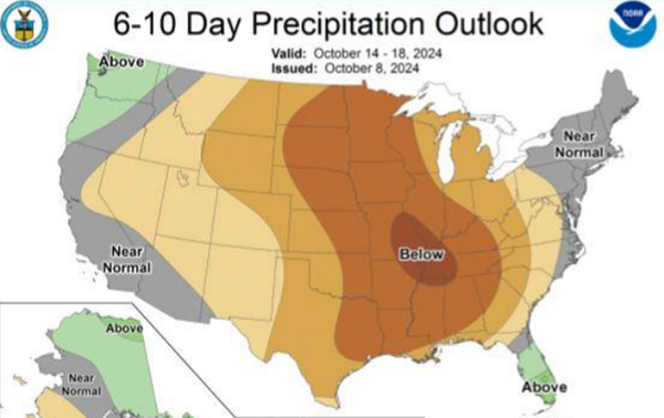
Just like this week, there's still no mention of any meaningful chance for rain next week. In fact, western Kentucky is in the bullseye for the least chance of rain nationally over the next 10 days. Only Florida, Washington and Oregon have a longterm likelihood of above average rainfall.
Advertisement
Still no sign of rain next week, but highs will fall into the 60s
Advertisement
Latest Local & Regional
Local & Regional
2 hours ago
Local & Regional
18 hours ago
Local & Regional
22 hours ago
Local & Regional
23 hours ago
Local & Regional
yesterday
ADVERTISEMENT
Most Read >
ADVERTISEMENT
Latest Local & Regional
Local & Regional
2 hours ago
Local & Regional
18 hours ago
Local & Regional
22 hours ago
Local & Regional
23 hours ago
Local & Regional
yesterday
Advertisement
ADVERTISEMENT
.png?lang=en-US&width=600&height=386&ext=.png)


