
A significant block of summer heat and humidity will settle over the quad state for most of next week, after a round of thunderstorms this weekend.
A slight chance for showers and thunderstorms will move in Wednesday night and ramp up to a 50-50 chance on Thursday afternoon. An isolated strong or severe thunderstorm cannot be ruled out by Thursday afternoon and evening.
A greater likelihood for showers and thunderstorms will continue on Friday into Saturday. Again, a few strong or severe thunderstorms are possible Friday afternoon and evening.
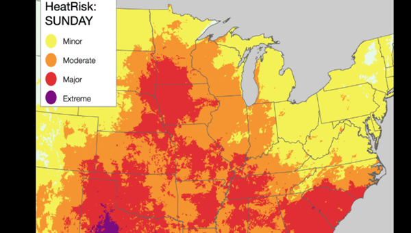
Dangerous heat and humidity will arrive Sunday and continue through most of next week. Daily afternoon highs near 98, and heat index values of 105 to 110 degrees are forecast in the first half of next week, and will likely trigger heat warnings from day to day.
NOAA's extended outlook to the Fourth of July points to Kentucky and Illinois as being in the bullseye of a six-state swath of the Midwest that will continue to see the hottest departure above their usual temperature ranges.
Advertisement
Heat wave moves in next week, all the way to July 4th
Advertisement
Latest Local & Regional
Local & Regional
10 minutes ago

Local & Regional
11 hours ago

Local & Regional
12 hours ago

Local & Regional
12 hours ago

Local & Regional
13 hours ago

ADVERTISEMENT
Most Read >
ADVERTISEMENT
Latest Local & Regional
Local & Regional
10 minutes ago
Local & Regional
11 hours ago
Local & Regional
12 hours ago
Local & Regional
12 hours ago
Local & Regional
13 hours ago
Advertisement
ADVERTISEMENT